Sunday and Monday August 16 and 17, 2015 Previous Post:
Lewis Mountain Campground Another Kind of Trial Angel and Following the Evidence
Shenandoah National Park, Virginia
SUNDAY
We have camped in both Big Meadows and Loft Mountain Campgrounds in Shenandoah National Park. We have visited Mathews Arm and decided we cannot camp there so the last of the campgrounds that we have not stayed in is Lewis Mountain. So today we move there and find a lovely pull through site with what we hope will be enough sun. We also discover a BIG bonus. With our antenna and booster, we can get both internet and cell service in the rig. That’s a first for us all summer so far.

Lewis Mountain is a very small campground, 33 sites which are all walk in only. It also has no dump site and no where to take on potable water. So we do both of those before leaving Big Meadows and will have to return to Big Meadows or Loft Mountain when we leave.
Lewis Mountain also has a very interesting history and like the story of the folks whose land was taken to form the park, the Visitor’s Center is now telling this story as well. That they are no longer white washing these two parts of the history of this park makes me very happy.
As you can see from this picture off the NPS Website, Lewis Mountain was the campground for Negroes in this “separate but equal” Jim Crowe state. There is an excellent article by Reed Engle a park Cultural Resources Specialist who is an expert on the history of Shenandoah National Park and is featured in their Visitor Center Film. Definitely worth the read if you are interested in the huge fight between the state and the Federal Government over segregation.
Lewis Mountain was separate but hardly equal given that the other campgrounds have over 175 sites and dump stations and water take on. But Lewis did have a campground, 4 cabins and a Lodge with a restaurant which is now sadly only a camp store. The restaurant was so popular that the whites complained that they couldn’t use it. The story about that is just amazing for its audacity and arrogance.
It was a long battle between the state and the federal government regarding the integration of Shenandoah National Park and took until after WWII to resolve. Some great pictures of the various accommodations including the original Lewis Mountain Lodge, Cabins and Campground can be seen here.

Today the Lewis Campground has 15 cabins, a camp store and the same 33 campsites. Here is our nice large pull through.


If you look at the history pictures you can compare them with the cabins today.


The inside of what used to be the lodge and is now the camp store today.

Food, clothing, camping gear or rent cabins here from the current concessionaire. The campground is run by the park.


The one bath house for 33 sites and an information board with the story of Lewis Mountain facilities.


The campground is mostly tenters and popups who understandably aren’t crazy about RVs with generators. I heard one ranger tell the story that when an RV generator was finally turned off in the evening after running the full allowable hours from 4 to 7pm everyone in the area cheered and clapped.


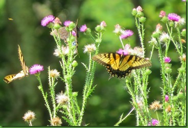
Here is what we have in in the field behind our backyard. Everybody loves the thistle.


MONDAY

This is Hike #16 on the quest to hike the entire AT through Shenandoah National Park in day hikes. Today will take us through the southernmost part of the central section of the park. We’ll end up at Route 33 (the bottom blue arrow) which is the road to Elkton to the West and Stanardsville to the East.
We begin at the top blue arrow, the Pocosin Fire Road. The road goes down past the Pocosin Cabin and to the Pocosin Mission. We’ve done that hike and the post is here. Today we take the road to where the AT crosses and turn right on the AT.

We’re headed for the crest of Baldface mountain. 
I spot some unusually tall and straight Indian Pipe. Most of them have disappeared for this season

The trail leads that up is quite rocky. At some points it is a bit difficult to see where the trail goes over the rocks.


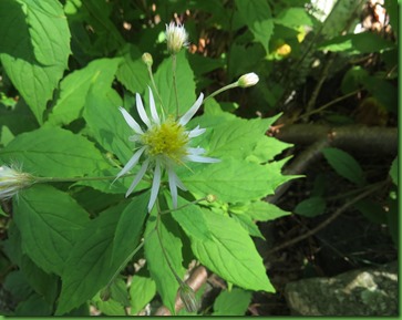
Even as fall seems to be just on the cusp, there are still wildflowers in the woods. I assume these are some sort of aster. Their leaves don’t look like wavyleaf aster.

But I know for sure that these are spotted jewelweed. There must be poison ivy nearby as jewel weed is nature’s poison ivy treatment.

These have the same shape as the spotted jewelweed but they aren’t the same color. Perhaps they are more immature? Although they don’t look immature. I didn’t know that jewelweed came in other colors.


Sunflowers are so cheery wherever they grow. These woodland sunflowers have an unusual gold and green center.

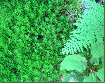
The mosses and ferns continue to be outstanding.

Mushrooms and fungus are becoming fewer.


Hope these are not bad guys in the forest. Any entomologists out there?


We make it to the crest but there isn’t a view so we start back down and discover some shelf and other log mushrooms we haven’t seen before.

You can see how much taller David is than I. He’s just standing on the trail next to me taking this picture of me taking the next picture.


So many shapes, sizes, colors and designs. Doubt I could ever be a mushroom specialist.

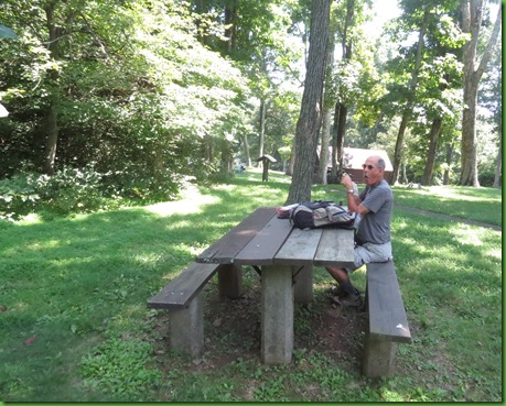
The AT bottoms out and crosses the South River Falls trail. I have hiked to the falls but David has not so on another day we’ll have to put that on our agenda. The falls trail goes to the left and a trail to the South River Falls picnic area goes to the right. We stop for lunch.

I know these are branches on this tree but they sure do look like antlers to me.


Just before we reach the Route 33 Swift Run Gap entrance to the park and the end of our hike, our trail book tells us we can take a trail 100 yards to a mountain cemetery. The trail isn’t obvious and we miss it the first time. We get to the end post for this section and haven’t seen it so we turn around and walk back. I walk right by it again but Eagle Eye David spots an odd stake in the ground across from a tiny little sort of thing that looks kind of like a trail. We take it and as we get closer it begins to look more like a trail.
It seems odd to find a chain link fence deep in the woods. The cemetery has apparently just been seriously cleaned of what must have been a lot of wild growth since the ground is now dirt. One small section is fenced in. In the fenced in area are only 3 stones.


1932 was clearly a sad year for local families. One of the stones is for Dessie W Shifflett “Mother” 1892-1932. Next to that is the stone for Baby 1932-32. We assume Dessie died in childbirth at the age of 40.


The third stone is for William Sullivan who also died in 1932. Perhaps there was influenza or some other disease that year.

In the main graveyard are a number of the same sort of stakes which indicate that some archeologists have been here and picked up artifacts like belt buckles and other things. So we assume they are the ones who cleared the area.
You can see one of the sticks between the two Knighton Tomb Stones. This appears to be three generations of the same family.

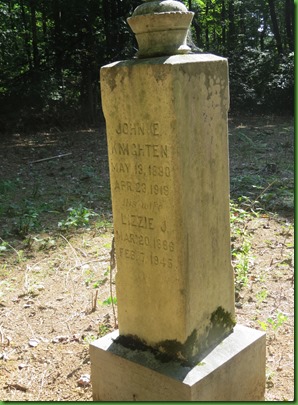

There are tombstones with births as early as 1841 and 1856. Ages as old as 80. There seem to be an unusual number of children’s stones. There are again many simple field stones marking head and foot with no dates or names at all.

Ages 6 and 5.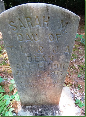

Leaving the cemetery we find what we think may be a Paw Paw tree. The leaves are huge. Could it be a cucumber magnolia?


One last tree hug before reaching the car.


The Swift Run Gap entrance to the park which is where we have parked the car for this hike, is the one we use to go to the Cancer Center each Wednesday. And on every trip we drive by a sign on the Skyline drive with an arrow saying Dean Cemetery. We have always said we wanted to stop but never do. Today we do.
The road is gravel and wide and well maintained. There is a parking lot right off of the drive but the road continues all the way to the cemetery and there is a small parking lot at its end. We walk from the lot by the road.
I’m not sure what the Dean Family has done to get such a large graveyard with such an easy access. It is quite a contrast to the little graveyard we have just seen where the path is barely visible and it looks like no care has been taken for years although there was a burial there in 2006.
The cemetery has a flag pole in its center and a welcome box with flags around.
The Welcome page (right) is interesting to read. In part, it encourages people to get involved in the maintenance of the graveyard saying that if it is not kept up then the land will revert to the park service and the cemetery will be allowed to grow over. I am looking at the log book which has dates and descriptions of clean up work and mowing done by members of the family. They are quite frequent.


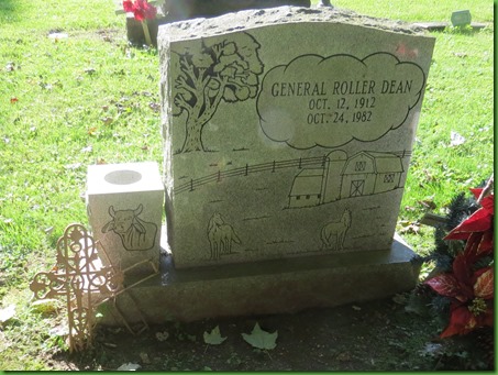
Some of the stones here are very elaborate with colored drawings and pictures of the deceased and in this case his wife who is not yet deceased.

Sadly there are young people here. The detail on this stone is amazing. Enlarge it and see for yourself. I wonder if one of the Deans is a tombstone carver.

The light really interferred with this photo but the detail and the cow were just too compelling not to include.
This is a much larger graveyard, well cared for, with dates from the 1700’s to this past year. As final resting places go, this one in the Blue Ridge Mountains is lovely.


